
پرونده:Greatvalley-map.png

اندازهٔ این پیشنمایش: ۵۸۷ × ۵۹۹ پیکسل. کیفیتهای دیگر: ۲۳۵ × ۲۴۰ پیکسل | ۶۲۴ × ۶۳۷ پیکسل.
پروندهٔ اصلی (۶۲۴ × ۶۳۷ پیکسل، اندازهٔ پرونده: ۶۶ کیلوبایت، نوع MIME پرونده: image/png)
این پرونده در ویکیانبار موجود است. محتویات صفحهٔ توصیف آن در زیر نمایش داده میشود. |


|
این map نگاره میبایست با استفاده از گرافیک برداری اسویجی فایل بازسازی شوند. این چند مزیت دارد؛ Commons:Media for cleanup را برای اطلاعات بیشتر ببینید. اگر حالت برداری آن در حال حاضر موجود است، لطفاً آن را بار کنید. پس از بارکردن یک اسویجی، این الگو را با {{vector version available|new image name.svg}} جایگزین کنید.
|
خلاصه
| توضیح |
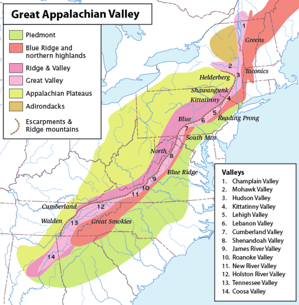
Map of the Appalachian Mountain physiographic regions, highlighting the Great Appalachian Valley, naming the main valleys making it up and the main mountains on either side. Legend:
|
| تاریخ | (UTC) |
| منبع | |
| پدیدآور |
|
| این یک عکس دستکاری شده است به این معنی که به صورت دیجیتالی از نسخهٔ اصلی تغییر یافتهاست. تغییرها: converted loselessto PNG. اصل آن را میتوان در اینجا مشاهده کرد: Greatvalley-map.jpg.
|
من، صاحب حقوق قانونی این اثر، به این وسیله این اثر را تحث اجازهنامهٔ ذیل منتشر میکنم:
این پرونده با اجازهنامهٔ کریتیو کامانز Attribution-Share Alike 2.5 عمومی منتشر شده است.
- شما اجازه دارید:
- برای به اشتراک گذاشتن – برای کپی، توزیع و انتقال اثر
- تلفیق کردن – برای انطباق اثر
- تحت شرایط زیر:
- انتساب – شما باید اعتبار مربوطه را به دست آورید، پیوندی به مجوز ارائه دهید و نشان دهید که آیا تغییرات ایجاد شدهاند یا خیر. شما ممکن است این کار را به هر روش منطقی انجام دهید، اما نه به هر شیوهای که پیشنهاد میکند که مجوزدهنده از شما یا استفادهتان حمایت کند.
- انتشار مشابه – اگر این اثر را تلفیق یا تبدیل میکنید، یا بر پایه آن اثری دیگر خلق میکنید، میبایست مشارکتهای خود را تحت مجوز یکسان یا مشابه با ا اصل آن توزیع کنید.
سیاهه بارگذاری اصلی
This image is a derivative work of the following images:
- File:Greatvalley-map.jpg licensed with Cc-by-sa-2.5
- 2006-11-14T06:22:37Z Pfly 624x637 (394372 Bytes) {{Information |Description=Map of the Appalachian Mountain physiographic regions, highlighting the Great Appalachian Valley, naming the main valleys making it up and the main mountains on either side. |Source=I made this map
Uploaded with derivativeFX
تاریخچهٔ پرونده
روی تاریخ/زمانها کلیک کنید تا نسخهٔ مربوط به آن هنگام را ببینید.
| تاریخ/زمان | بندانگشتی | ابعاد | کاربر | توضیح | |
|---|---|---|---|---|---|
| کنونی | ۱۲ مهٔ ۲۰۱۰، ساعت ۱۵:۰۰ | | ۶۲۴ در ۶۳۷ (۶۶ کیلوبایت) | Perhelion | {{Information |Description=Map of the Appalachian Mountain physiographic regions, highlighting the Great Appalachian Valley, naming the main valleys making it up and the main mountains on either side. |Source=*File:Greatvalley-map.jpg |Date=2010-05- |
کاربرد پرونده
صفحهٔ زیر از این تصویر استفاده میکند:
کاربرد سراسری پرونده
ویکیهای دیگر زیر از این پرونده استفاده میکنند:
- کاربرد در bg.wikipedia.org
- کاربرد در bh.wikipedia.org
- کاربرد در ca.wikipedia.org
- کاربرد در cs.wikipedia.org
- کاربرد در da.wikipedia.org
- کاربرد در en.wikipedia.org
- Washington County, New York
- Great Appalachian Valley
- Allegheny Front
- Lehigh Valley
- Cumberland Valley
- Talk:Ridge-and-Valley Appalachians
- Lebanon Valley
- Kittatinny Valley
- Gaps of the Allegheny
- Template:User Appalachian diaspora
- User:Hike395/mountain bot diff
- Template:Infobox mountain/test versus status quo ante 3
- کاربرد در et.wikipedia.org
- کاربرد در fo.wikipedia.org
- کاربرد در frr.wikipedia.org
- کاربرد در fr.wikipedia.org
- کاربرد در he.wikipedia.org
- کاربرد در it.wikipedia.org
- کاربرد در ja.wikipedia.org
- کاربرد در lt.wikipedia.org
- کاربرد در ml.wikipedia.org
- کاربرد در pl.wikipedia.org
- کاربرد در simple.wikipedia.org
- کاربرد در uk.wikipedia.org